We make agricultural carbon measurable, provable, and investable.
GreenScope is the measurement, attribution, and intelligence infrastructure behind agricultural carbon markets in the Global South. Built for carbon project developers, governments, and climate funds.
Satellite data and causal AI for smallholder tropical systems where sensors are sparse, records are fragmented, and credibility is everything. Deploys in 4–6 weeks.
Agricultural carbon markets in the Global South are broken at the measurement layer.
Smallholder farmers across Africa and the tropics manage hundreds of millions of hectares of carbon-rich land. But the infrastructure to measure, attribute, and verify that carbon, credibly and affordably, does not yet exist at scale.
Too expensive
Traditional MRV relies on physical audits and consultant-led soil sampling. Projects under 5,000 farmers are economically unviable.
Too slow
Standard baseline-to-issuance cycles delay carbon revenue by one to two years. Farmer adoption collapses when income arrives too late.
Unverifiable at scale
Buyers increasingly reject credits without defensible additionality. The integrity gap between high- and low-quality credits now exceeds $15–30/tCO₂e.
i. The Phase 1 stack
Six public, peer-reviewed datasets integrated in Google Earth Engine. This is what the Murang'a pilot actually runs on.
ii. Why now
- Article 6 Host-country authorization now requires traceable, verifiable MRV at national scale
- Integrity crisis Institutional buyers are rejecting credits without defensible additionality
- Satellite parity Sentinel-2 and RothC reached production-ready accuracy for smallholder systems
- Registry demand BCR and Verra are actively sourcing dMRV methodology partners
Three layers. One infrastructure.
GreenScope unifies measurement, attribution, and intelligence into a single pipeline. Scalable across tropical geographies, built for the Global South from day one.
Measurement
Satellite · Uncertainty-quantifiedSatellite-driven, uncertainty-quantified carbon stock estimation across tropical agricultural landscapes. Built on Google Earth Engine using peer-reviewed public datasets, RothC 26.3 soil modelling, and IPCC Tier 2 quadrature for uncertainty propagation.
Attribution
Causal · Additionality-defensibleA proprietary causal model (technically a Bayesian DAG) that isolates the real impact of specific farming practices from rainfall, soil type, and landscape context. This turns a correlation into defensible additionality, making verification faster, cheaper, and more credible for high-integrity credits at smallholder scale.
Intelligence
Data products · Decision-readyLandscape-level carbon intelligence delivered as data products: to governments for climate planning, to fund managers for portfolio allocation, to registries for methodology alignment, and to agribusiness for supply-chain traceability. Revenue independent of credit markets.
From abstract infrastructure to concrete deliverables.
Every GreenScope engagement produces a defined set of outputs, designed for registry submission, investment decisions, field operations, and third-party verification workflows.
Carbon Baseline
Uncertainty-quantified carbon stock map across your project geography. Soil organic carbon, above-ground biomass, and total landscape carbon, with 90% confidence intervals at every pixel.
Additionality Report
Methodology-aligned causal attribution document connecting observed carbon change to specific farming practices. Built for BCR AFOLU submission, Verra VM0042 alignment, and Article 6 traceability.
Priority Zone Analysis
Intervention intelligence: which hectares to invest in first, which to monitor, which to improve. Sub-county ranking by carbon signal, investment readiness, and Zone A share.
Monitoring Updates
Continuous monitoring at seasonal cadence. NDVI trends, rainfall anomalies, and carbon trajectory updates flow into your existing workflows. No rebuild required.
Revenue Modelling
Scenario-based carbon revenue projections grounded in field-calibrated benchmarks (KACP), price-sensitivity analysis, and Zone-level credit issuance potential over 5-year crediting periods.
Portfolio Intelligence
For funds and institutional buyers: cross-geography carbon intelligence, due diligence outputs, and impact verification data that survives institutional scrutiny.
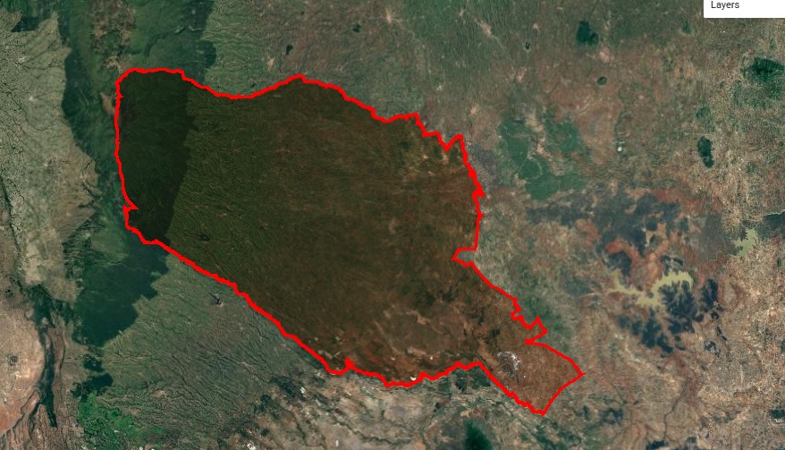
Murang'a County, Kenya. The first deployment.
Murang'a is our proof-of-concept pilot: the first end-to-end deployment of the GreenScope platform. Phase 1 ran on public datasets in under six weeks, producing a bounded, uncertainty-quantified carbon estimate across 92,329 hectares. The same pipeline deploys to any tropical agricultural geography in 4–6 weeks.
| Sub-county | tCO₂e | Zone A | Action |
|---|---|---|---|
| Kangema | 9.1M | 47.5% | Invest |
| Kigumo | 7.2M | 41.3% | Invest |
| Gatanga | 7.3M | 28.6% | Invest |
| Kandara | 4.0M | 11.4% | Monitor |
| Mathioya | 5.7M | 8.5% | Monitor |
| Kiharu | 5.4M | 5.0% | Monitor |
| Maragwa | 4.4M | 2.4% | Monitor |
What makes us different.
Four structural advantages, built into the architecture and not bolted on later. This is what makes GreenScope the measurement layer the tropical carbon ecosystem is building around.
Carbon data as infrastructure
Our outputs become the data layer that carbon platforms, government land-use systems, and ESG tools build on. Not another dashboard to log into.
Proof, not correlation
Our causal model separates real impact from seasonal noise. Buyers paying premium prices demand this level of evidence. Most MRV tools cannot produce it.
The ecosystem's measurement layer
Aligned with Verra, BCR, and Article 6, not locked to any one of them. Every new deployment strengthens our position as the neutral evidence layer.
The compounding data moat
Each deployment trains priors that accelerate the next. A competitor starting today has to rebuild what we already have across every geography we've touched.
Infrastructure for everyone building the tropical agricultural carbon market.
GreenScope enables project developers, verification bodies, registries, governments, and funds, without competing with any of them. The same platform outputs serve multiple buyer classes.
Project Developers
Reduce MRV cost by an order of magnitude. Access uncertainty-quantified baselines, causal attribution outputs, and monitoring updates designed to flow directly into your verification body workflow. Makes VVB/CAB review faster and audit risk lower.
Request a demo→Government Institutions
County and national-level carbon intelligence for climate planning, NDC reporting, food security decisions, and landscape-scale regenerative agriculture strategy. Decision-ready, not just dashboard-ready.
Explore a pilot→Climate Funds & Investors
Portfolio-level carbon intelligence for fund allocation, impact verification, and due diligence across African and tropical agricultural investments. Evidence that survives institutional scrutiny.
Request data access→Registries & Verifiers
Methodology-aligned outputs designed for BCR AFOLU, Verra VM0042, and Article 6 frameworks. GreenScope makes verification faster, cheaper, and more defensible. This gives VVBs and CABs the evidence layer they need to issue high-integrity credits with confidence. Built with the ecosystem, not around it.
Discuss alignment→Watch what we built.
Let's talk about your tropical carbon project.
Whether you are a project developer, registry, government institution, or climate fund, reach out to explore what decision-ready carbon intelligence looks like for your work.
- i. Request a demo of the dMRV platform and carbon intelligence outputs
- ii. Explore piloting the platform in your geography or project portfolio
- iii. Engage GreenScope for methodology co-development or registry alignment
- iv. Discuss strategic partnership or platform integration opportunities
